Driving thru Vicente Guerrero on Hwy 1 on the way to San Quintin we were startled to see a long procession of cars and wondered what was going on. People were dressed in showy garb. I was trying to get my camera out, but not fast enough. There were people standing on top of cars, back of truck beds and 3 people were standing on top of a large vehicle. It was not until they were almost passed that I realized they were on top of cages with a tiger, lion and leopard. Tom says OSHA would definitely not have approved of them standing on top of moving trailers.
About Us
- Marianne and Tom
- We are both retired. Built a house near a beach in Mexico to spend the winter away from the cold and snow. Have another home in Washington on the Pend Oreille River where we spend the summer. We divide our time between the two homes.
Friday, November 4, 2011
Tuesday, November 1, 2011
Roads in Baja
![]() | |
| Oh boy, look at those tires on white lines |
![]() |
| San Quintin here we come |
We thought Hwy 66 in OR was narrow. Baja roads are worse. The shoulders drop off sharply and the white line is usually the edge of the payment. The white line in many instances is part of a crumbling pavement. When you pass an oncoming big rig each of you puts the right wheel on that white line. The original paved road in Baja is 9 ½' compared to the US of 12'. Our 8 ½' foot wide motor home has mirrors that stick out 10 inches on either side . So when our tire is on the white line the drivers mirror is hanging over the yellow line. Only inches to spare between the rigs. There are still several hundreds of miles of these old roads. Tom loves it when we get to new road that is wider. Then you come to areas where they are putting culverts into the new payment. They cut into the road and mark it with half of a tire painted ice box white. No room for passing there, one of you has to stop. Then there is construction, the detour is loose dirt with whoop-d- doo's and when it rains makes for a big mess. We also are learning that, especially, in a motor home, you don't get places fast. What we thought would take 2 hours can turn into 5, with the roads being what they are.
![]() |
| On route to Santa Rosalia |
![]() |
| On the Road to Guerrero Negro |
Ensenada,
![]() | |
| Small vs large fishing boat |
On our way to Ensenada is where we heard the big bang, that we later learned was our tire blowing out. Coming into the city we had two choices, but which road do we take, we can't read the signs. We take what we think is the correct road and it puts us in the residential area. Now construction, again, but this time we have to take a dirt road between the homes. We make it back to the main road and try to find our turn for the campground. If you see a sign for the turn off, turn! There will be no further signs, that sign is where you have to turn. We made it through our first day and found our campground. We are the only ones in the campground, which will be a recurring theme throughout our trip. As we progress thru our trip we see many campgrounds that have gone under because the tourists are not coming any more. There is an estuary that again I didn't get to kayak in. There is a subdivision between the bay and estuary that had fallen on hard times. Only half completed and many of the homes had for sale signs. Another sign of the times. No tourism. Dan, Lisa and their caravan showed up at this campground. This is where we found out the osmosis system Tom had installed will not filter out the salt. One taste is all it took to realize we wouldn't be drinking the water from this RV park. Off to buy BIG bottles of water. This is also where we purchased our Mexican Cell phone and USB internet stick, so we can have an emergency number and wi-fi. However, it doesn't always work as we later found out. There have been days... when we had no communication.
![]() |
| Punta Estero |
![]() |
| Looking back to Punta Estero |
Tecate
We had heard horror stories about searches and having the correct paperwork. We pulled up to the crossing and were surprised! They waved us through without a stop, no inspection. Now down the hill to a T intersection and narrow road. Tom's first taste of driving in Baja. Our first gas station. No English and thank goodness they accepted our credit card. We hadn't gotten pesos yet. Tom read that you need to order fuel in liters only because if you order in pesos you will get ripped off. He can explain why, I think I understand, but he could tell you better. You also need to stand next to the pump while the attendant pumps the gas. No you can't pump your own gas and you're expected to tip the attendant.
Monday, October 31, 2011
Portrero Campground, CA
This was located just a few miles from Tecate, Baja where we crossed into Baja. There is nowhere to park a large motor home at the crossing so we drove to the border in the jeep and walked across. We needed to get visitor visas. The MX immigration office was not well marked, but we located it. The officer spoke very limited English. We got the necessary paperwork and then had to walk downhill several blocks to the bank to pay for the visa. We waited, in what we hoped, was the correct line for over an hour. Note, do not go to the bank on the last day or first of the month when everyone gets paid. Again, the cashier spoke limited English. Tom attempted to get cash from the ATM with no success. We hope that another bank will take our debit card or we will have a short Baja experience. This is the first time we came across Dan and Lisa who run “Baja Amigos RV Caravan Tours.” They were a great help with telling us which RV places were better to stay at on our trip south.
Friday, October 28, 2011
El Cajun, CA
We picked up the foot for the jack. The bolt that came with the foot didn't fit! Tom went to town and purchased several bolts in the hopes that one would work because the bolt store closed at noon on Saturdays. He wouldn't be able to get back if he had selected the wrong one. So now we have an assortment, in case we need them. The resort had a swimming pool and hot tub. Nice to relax in, while we did our laundry.
Tuesday, October 25, 2011
Bristlecone, CA
This was a day trip from Keough's Hot Springs. They sit high in the mountains at 10,000 feet. It was cold, but the view was fantastic. Some of the trees are 4,000 years old. The visitor center had burned down and was in the process of being rebuilt. We attempted to continue higher on a dirt road to see another stand of trees, but after 5 miles and another 4 to go, decided it probably wasn't worth the slow bumping along. Monday, October 24, 2011
Keough's Hot Springs, CA
Oh, so nice to be able to soak. We spent a couple of days here. The board we used to put under the jack finally split. The weight that is put on these jacks are amazing. The camper next to us was the son-in-law of the owners and he ran and got an old mower blade to put under the jack. We used it until El Cajon, much stronger than a board. The owners have placed many old tractors, wagons and such around. They had tents on platforms you could rent. The insides had queen size beds, a desk and portable heater. There were firepits and they supplied wood which were held in the old mine buckets There were some old, what used to be paved roads just prior to the hot springs where people were boon docking. One lady was in a small motor home and had been traveling with her dog for a year and no specific place to be. 
Sunday, October 23, 2011
Bodie State Park, CA
![]() |
| Old post box |

This town sits at 8,000 feet and is about 30 miles from Mono Lake on a gravel road. This is an old silver mining town. There were many people visiting the site, especially since there were no camping facilities and they closed the town down at dark. I was in hog heaven taking pictures, as were many other people. The camera buffs were out in full force. I could have stayed a couple of days looking around. Some of the buildings still had furniture, but you couldn't go into the buildings. There is a museum, which happened to be closed the day we were there. One building was an old Oddfellows Hall. Don't think that group even exists any more. A place to come back to and spend more time.
Saturday, October 22, 2011
Mono Lake, CA
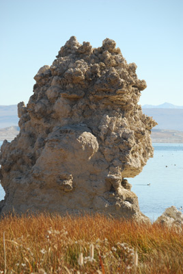
The lake looked so blue driving down the hill into town. The pillars (tufa formations) coming out of the lake were a stark contrast to the lake color. I again wanted to kayak
around to explore these interesting formations. But not this time, we were headed to Bodie State Park. The lake has been dropping in depth because Los Angeles has been withdrawing from the lake and it has become salter because there is less volume of water. There is now a effort to bring the water up 10 feet. This will not be a quick fix, the time line is 10 years. The lake fluctuates, the rain and snow also are a factor as to how much the lake rises. It would be interesting to come back in 10 years and see the changes that have taken place. The day after
we left we understand it turned really cold.Wednesday, October 19, 2011
Lava National Monument, CA
![]() |
| Looking Out |
![]() |
| One of those small spaces |
If you are a spelunker, theses caves would definitely be fun. The campground had, maybe 5 campers in two sections. It was very quiet, the stars glowed at night. Driving around we felt we were on another world, so quiet and the landscape looked like something out of a si-fi movie. In any of the caves I was the only one there. A flashlight was a necessity and you could get a good one from the visitor center, which of coarse I didn't do, not realizing just how dark and lonely it would be in the caves. My flashlight was a small maglight which left many nook and crannies in the dark and not much glow on the uneven ground to walk on. I didn't make it very far into the caves, a little to dark for my taste. The caves were rated by easy, medium and difficult. The easy ones were enough for me. There were still many boulders to climb over and tunnels that were small. There were many places I looked down a hole and said, no I'm not climbing down there. One cave had ladders to climb down into levels below. Too dark for me! A buddy would have been nice. Tom was sitting in the car reading while I explored or hiked the trails to a cave.
Saturday, October 15, 2011
Starting Out
We purchased the motor home at the end of January 2011, so it is still a new experience for us, different from towing a trailer. We now also have a car in tow, which makes the rig 60'. We now really have to watch the corners to make sure everything clears. Tom loves the fact that he doesn't have to go outside to crank the levels down. He now just pushes a button and if it's not right he can push another couple of buttons. That implies, however, that we have all the levels and feet. Somewhere between home and Albany, OR we discovered we had lost a foot. We had to order one from the factory as the RV places didn't have one. Now, where to have it delivered, as we had no set plans and no specific towns we where going to stop at. Our last stop in a city before we cross into Baja was at El Cajun, so that seemed the logical place to pick it up. Tom called an RV store in El Cajun and they were willing to order the part and have it waiting for us when we got to town. In the mean time we put a board under the jack.
In lower OR there is a Hwy 66 that crosses over to CA Lava Beds, which seemed like a shortcut. As we turn onto the road it said not recommended for vehicles over 60'. OK, we are not over 60'. The road twisted and turned and was what we thought at the time narrow. Have you ever ridden in the passenger side of a motor home? I was looking straight down the cliff, could not see the road or white line. To say I was nervous would be an understatement.
![]() |
| Klamath River |
At the crest of Hwy 66 we came across Klamath River. I was itching to get the kayak out and paddle. But, we were on a time frame and the campgrounds were closed waiting for snow. We came across this sign giving some history. (You will have to enlarge to read it, but I found it interesting.)
Subscribe to:
Posts (Atom)